Start: Prudhoe Bay, Alaska (North America)
End: Ushuaia, Argentina (South America)
Route selection preferences: single track / dirt roads and wild striking landscapes
Exporting the GPXs: click on three lined menu in top right, then select “Export selected map data…”. Please drop me a comment if any issues with download! (Tested only on desktop browser).
(Long straight lines are generally where google maps couldn’t compute the route. Or occasions where I was compelled to take a ferry, sailing boat, dug out canoe, or the (rare) bus (New Mexico to California))
North America and Central America are two big gpxs and the South America is divided by sections (as my route documenting improved).
GPS Navigation: For Android, I used AlpineQuest. For iphone, I have heard Gaia GPS is excellent.
North America section, with post links – (I’ve yet to do this for South America)
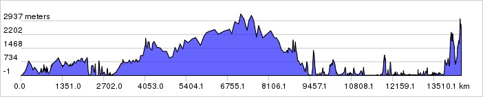
North America elevation profile (to Quetz. Guatemala). Distance: 13100km,Total elevation gain: 236km
Central America, with post links

Central America elevation profile: Quetz. Guatemala to Cartí, Panama. Distance: 3800km.
Wow!
Amazing! What a trip!
I have been checking your site often and am concerned that you have had no new entries. I sincerely hope that you have not come to any harm and are just too busy to update…
I’m well thanks Adele. Just having a break from the trip. Returning towards the end of the year to continue.
Oh thank God and thanks for letting me know. I am really relieved as I had imagined all kinds of horrible scenarios. Enjoy your break and I am looking forward to following you again when you continue… The very best to you…. I am off to Punta Perula Oct 28 and back to Canada April 15.
Hi Nick – this is an amazing adventure!
I am planning to spend 1 month in Ecuador in June 2017, and follow the routes that you did. So all the information/videos on trip in Ecuador is really helpful! I have two questions
– when trying to upload your Ecuador gpx files into Google map I got an error. Would you know what might cause this?
– as part of your trip you followed in Ecuador you followed water channels, and crossed some really narrow and dangerous looking bridges (I am sure remember this part 🙂 ). I was wondering whether you have any recommendations on how to avoid this part, i.e. whether you could let me know at which point I should diverge from you route to go around, and avoid, the bridge.
Many thanks for your help!
-Peter
I just figured out how to upload the gpx file – it worked 🙂
Hi Peter, I have detailed a way to avoid the water channels after Chimborazo in the comments section here:
http://nicholasgault.com/2016/04/22/avenida-de-los-volcanes-trans-ecuador-3-cotopaxi-chimborazo-quilatoa/
Cheers,
Nicholas
Hey Nick
Love your trip! Your website looks great too.
We’re also cycling Alaska to Argentina, currently in Bozeman Montana.
We’d love to get a map like your showing our progress onto our site http://www.weneedmoreheroes.co.
How might we best do that?
Thanks
G
Hi George! I used gpsvisualizer.com. It’s a little fiddly but they have instructions on the site. From memory, you upload your gpxs to gpsvisualiser then you download it in html form. Then you must upload this html to your server in the folders where your website is hosted and link to it from your web page. Good luck! If you get bogged down on something specific you can write to me.
Cheers,
Nicholas
Hi Nick, looks like an incredible trip! I’m planning a shorter journey from La Paz to Cusco to Lima and found your site – you look well organized when it comes to route planning! I tried to export the GPS tracks using the visualizer and can’t seem to get them to export (even one at a time)… Any chance you can send them another way or share a different link? I’m trying to download Rio Blanco to La Paz on your map. My email address is conor.canaday1@gmail.com if it’s possible to share! Thanks much!
Hi Conor, sorry for the issues you had downloading. It does seem a little ‘buggy’ although somehow it worked for me (sent through to your email – let me know if you don’t receive it). I may have too many gpxs on there for gpsvisualizer to handle, hopefully I’ll get a moment soon to work out what’s wrong.
Hope you enjoy your trip, it’s a great route!
N